Ultimate Cross Country – Part 2
By Steve Mayotte


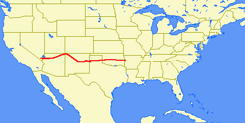
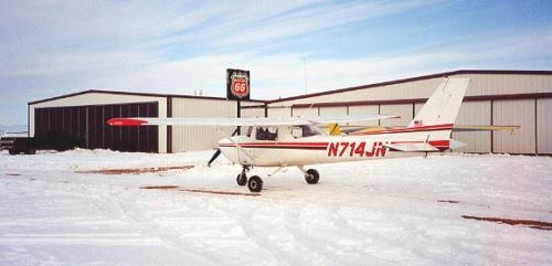
Chapter 2 Route: Jean, NV to Fort Smith, AR
Day 3 – Friday December 29, 2000
Thomas and I went down for breakfast at roughly 0530. Every route in the hotel passed through the casino. Was it my imagination or were the same people I saw yesterday still here on the same machines? No matter. I found the whole thing disturbing and didn’t wager anything.
We checked out and took the long walk back to the plane.
Was that a puddle of fuel under the engine? Is the flashing beacon on the tail not flashing? Is the primer not working at all? The answer to all 3 questions was “yes”. Oh my.
The engine started with great difficulty. Having no primer was a problem, but not a show-stopper. We could live without the beacon. The gas leak wasn’t too bad. My plan was to keep an extra sharp eye on the fuel gauges. We refueled at the 24 hour pump and lifted off at 0645.
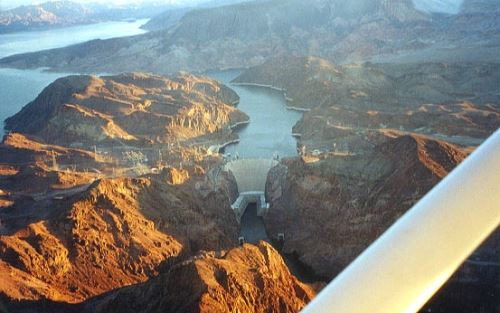
The initial heading was due east and the sun angle was brutal. Being less than 20 miles from Las Vegas’ McCarran International and its Class B airspace, we needed to pay strict attention to our location and our altitude. We avoided the terrain below and the restricted airspace above and crossed over the Boulder City (61B) airport at 0707. From there it was on to the Hoover Dam. The sun angle was still awful, but that dam was quite a sight. We flew out over Lake Mead and stayed down in the passes. At 0724, the left wing was in Nevada and the right wing was in Arizona. Rocks to the left, rocks to the right, and only water below. I called the place, “Lake Mead Narrows”, and it was narrow, I assure you.
From here, we followed the GPS to Grand Canyon West (1G4). If you look at a sectional, you can’t really appreciate just how close this airport is to “the edge”. We landed at roughly 0800. The whole airport had a definite slant. A friendly fellow chocked our wheels and pointed us to the bathrooms.
Native Americans own this place and make a living by selling rides over the Canyon in helicopters and Twin Otters. We were politely advised to beat it by 10AM because we were parked in a spot reserved for a Twin Otter.
Sitting at 4775’ above sea level, this was our first experience with a high altitude departure. The take-off run was a bit long perhaps, but we lifted off without difficulty at 0916. We circled around and headed southeast towards the Peach Springs VOR (PGS). The scenery was amazing, but if you think I had forgotten about our engine trouble the day before, you’d be mistaken. I was actively looking for “off airport” landing sites—just in case. To my surprise, there were plenty of places.
At the southern-most point of the canyon, we turned away and headed straight for the Grand Canyon National Park Airport (GCN). We touched down at around 1030.
Tom and I agreed that GCN was a happening kind of place. They had two FBO’s. Perhaps we could get our broken items repaired. Nope. If you had at least 3 blades on your propeller(s) and burned Jet-A fuel, this was the place for you.
A nice fellow took out our flashing beacon bulb and tested it. There wasn’t a mark on it, but it had no resistance (i.e., dead). Unfortunately, he had no replacement. The guy at the fuel desk gave me a form, and asked me to point out how much fuel I wanted it what tank. The form had a sketch of a plane with 2 tanks in each wing, tip tanks, and a fuselage tank. I slide the form back to him. “Fill it. It’s a Cessna 150.”
“Sorry”, he said sheepishly, “you guys have the smallest plane I’ve ever seen here.”
Our chances for finding lunch didn’t look too good today, so we loaded up on vending machine junk. The weather was cool and crisp. There were no clouds and the sky was deep blue. Simply amazing.
We hopped back in 4JN and started to taxi. Naturally, we had parked at a spot that was just about as far away from the active runway as is possible. The runway was 9,000 feet long and we needed to go to the opposite end. With nobody in front of us, I opted for a high-speed taxi—almost 40 knots. Tom cautioned that we might fly. Not a chance, 4JN felt like she was glued down. GCN has a big sign that says, “CHECK DENSITY ALTITUDE”. At 6606’ above sea level, they are already high. If the temperature is above 59°F, the air thins out and the plane can fly as if the altitude (i.e., the density altitude) is even higher.
Today was colder than 59°F. It was my guess that the density altitude was around 6000’.
We were cleared for take-off and I took the active runway. With the brakes jammed on, I went to full power and leaned for the maximum RPM. I released the brakes and we started rolling. Perhaps that fuel guy put fuel into tanks I didn’t know I had. We were rolling like a fully laden B-52.
We went past the “8” board (indicating 8,000 feet of runway left), then the “7” and the “6”. Finally, with the “5” clearly in sight, the airspeed indicator nudged “60” and I rotated. 4JN struggled into the air at 1133.
Our climb rate was only 100-200 feet per minute. I double-checked everything and found nothing amiss.
“Come on baby. You’ve got to do better than this,” I said very seriously.
“How close are the trees?” I asked Tom.
“REAL close,” he said nervously with his voice rising, “I can make out individual needles.”
I had asked for a right turn out. That would put us on course for Tuba City (T03), our next checkpoint. Forget that.
If we had one of those talking airplanes (like an F-16), the voice would have been saying, “Terrain. Terrain.”
The only answer was to claw skyward straight ahead. Our airspeed was stuck at 65 knots which yielded what the book calls “the best climb rate”. The GPS indicated a number in the 50’s. How will we ever get home at this rate?!?
After about 5 minutes of struggle, the terrain straight ahead wasn’t a problem. In fact, it fell away. We were over the Colorado River and IN the Grand Canyon. Turning east (and out) still wasn’t an option. By now, the oil temperature gauge was well on its way to indicating “overload”. Not sure, but I think I heard a voice with a Scottish accent say, “Captain. I’m giving it all she’s got!”
One couldn’t deny the view. Tom was snapping pictures like crazy. We wanted to see the Grand Canyon and damn it, we were seeing it. It was very, very impressive.
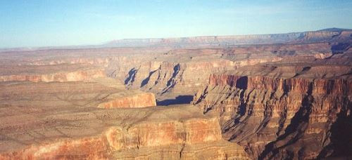
One also couldn’t deny all the pointed rocks and the freezing cold water almost a mile below us. I remember telling Tom, “If the engine quits, we’ve had it.”
Obviously, the engine didn’t quit. It seemed to take forever, but it was more like 20 minutes. We finally climbed out of the canyon and turned east to Tuba City. The airport passed under us at 1204.
We switched to the Denver Sectional (our 5th) and followed Route 160 to Kayenta (0V7).
The airport fell behind us at 1251. From there it was on “4 Corners”. That’s were Utah, Arizona, Colorado, and New Mexico all meet. My plan was to fly directly over the little monument that’s there and put 4JN into 4 states all at once.
Never saw it.
I misread the chart and thought “4 Corners” was at 37° N 109° W and programmed the GPS accordingly. It’s really at 37° N 109° 3’ W. We missed it by over 2 miles!
With 20-20 hindsight, I can say, “I blew it.” At the time, I had no idea what happened.
We both agreed to forget it and head for Farmington, New Mexico and the Four Corners Regional airport (FMN). As we drew closer, I got the ATIS and dutifully called the tower at about 10 miles out. There was only one problem, we couldn’t see the airport, even though the GPS was telling us exactly where to look.
We were told to call when established on the right downwind.
The GPS distance dwindled down to almost nothing before we figured it out. The airport is on top of a mesa. I hastily called the tower.
“Four Juliet November. Not in sight. Continue downwind.”, came the puzzled reply.
“Look up. We’re really close.”, I said, feeling very foolish indeed.
“Four Juliet November. Cleared to land.”
I made one of those full-flap, turning, diving approaches that only a 150 can do.
We landed at 1359 and taxied to Four Corners Aviation.
I’m sorry to report that I didn’t write down any names, but the guys at Four Corners were awesome. The line guy brought a mechanic out to talk with us. I gave him the repair list (leaking fuel strainer, burned out beacon, clogged primer).
“No sweat,” I was told.
Tom and I went into the office to look into getting a hotel room and a car. Almost at once, I looked out the window and saw 4JN get whisked away. The fellow at the desk took care of the hotel room straight away. We walked next door to the passenger terminal for a car.
We weren’t gone long. Upon our return, Tom and I were directed to the hanger. It was spotless and to my delight, the work on 4JN was already done. The cowling was being screwed on as we walked in. I asked about the ELT (Emergency Locating Transmitter). The remote control didn’t seem to work. A cover in the tail cone was pulled and the device was tested manually. It was fine. That was good enough for me. We could figure out the problem with the remote at home.
The day hadn’t turned out according to plan. We logged only 5.6 hours and covered roughly 360 miles. It was still early (around 1530). We could have kept flying.
No way. I was pooped. We’d crossed into the Mountain Time Zone and had already lost an hour. Even with our feet on the ground, we were still 5,500’ above sea level. I’d been to Denver a year earlier. Being “high” (i.e., the lack of oxygen) wears you down.
Our repair bill would be ready for us in the morning. 4JN would be left in the heated hanger overnight. Starting would be easy, for a change.
Tom and I headed for town. Unlike our previous stops that looked like “anywhere USA”, Farmington had a distinct Southwestern feel. We found the hotel, checked in, and set off in search of food.
Given my permission, Thomas would have us eat at McDonald’s every day. “No,” I told him, “we need to experience ‘local color’”. Oh boy. That didn’t sit very well with him. We found some greasy spoon kind of places that looked a bit suspect. Although, from my experience, the places that look so-so usually serve the best food. We also found a representative example of every food chain in the country. We settled on a 50’s looking drive-in kind of place called “Sonic”. In reality, it was a chain too, but we’d never been to one before. By golly, Tom tried something new and loved it.
Day 4 – Saturday December 30, 2000
By now, we’d flown 16.7 hours, covered almost 1200 nautical miles, and it felt like it. The combination of high anxiety, high altitudes, time changes, sleeping in hotels, and folding ourselves up into a 150 was really starting to hurt.
But, as Gene Krantz said during the Apollo 13 crisis, “Failure is not an option.”
We departed FMN at 0710 and headed 150 miles southeast towards Moriarty, NM (0E0). Along the way, we switched to the Albuquerque Sectional (our 6th) and skirted around the Class C airspace of the sectional’s namesake city. Almost as abruptly as the chart change, the reddish brown dirt we were flying over changed to the white of snow.
Tom’s English teacher is named Mary Moriarty (she’s also my cousin’s wife). Here was a whole town named after her. We just had to stop. The warmth of California was a distant memory. It was about 10° F when we touched down. The snow banks were quite high. In these situations, it’s nice to be in a high-wing airplane.
We bundled up and headed inside to the warm office. I looked out the window and saw the fuel truck covered in snow. It was also ancient, but I was assured that wouldn’t be a problem. A fellow went outside to start it up and scrape it off.
I passed the time of day with the manager and before too long, the old fuel truck actually moved! With a big hose in hand, the fuel guy climbed up on 4JN.
“What’s this about? Why isn’t he using a ladder?” I asked with some alarm.
“He’s young,” said the exasperated manager, rolling his eyes.
I zipped outside. By the time I got there, “youth” had already been replaced by “experience” and he was using a ladder.
Fueling complete, I selected an official Moriarty, New Mexico tee-shirt, paid my bill, and we headed out, departing at 0923.
About 10 miles east of Moriarty, we climbed up to avoid bumping into a place called Climes Corners. While we were still nowhere near sea level, that was the official end of our mountain avoiding. We were now over the great western plain and the terrain was getting lower every mile. Moriarty is at 6199’. We passed Santa Rosa (Q58 4790’) at 1007. Tucumcari (TCC 4065’) fell behind at 1042. Soon enough, New Mexico was gone and so was another sectional.
In one fell swoop, we’d crossed into the Dallas-Ft. Worth Sectional, the state of Texas, and the Central Time Zone. We landed at the Tradewind Airport (TDW) just south of Amarillo.
Whatever preconceived notions I had about Texas were crushed while on final approach. The temperature was in the 30’s and the sun was shining, but they had mountains of snow.
Tom looked into the luggage compartment and wondered, “Hey. Where’s my coat?”
I knew the answer at once, “Moriarty, New Mexico”. Luckily I had grabbed a card from the office. We could call and beg to have the coat sent home. Tom would have to wear his sweatshirt (and mine) for the remainder of the trip.
We touched down at 1238 and the wheels instantly kicked up a wave of slushy spray. Earlier in the flight, Tom had wondered why I had the wheel pants removed. It didn’t take a genius to see that under these conditions, they would have been filled with slush. At altitude, the slush would have frozen the wheels solid.
Unfortunately, it was another bad day for lunch. Vending machines were the only choice. We refueled and departed at 1305. While still on the ground, we had contacted the controllers of the Amarillo Class C airspace. Our requests were granted and we continued east.
The downside of stopping is that it sometimes creates more stops. The drinks secured in Amarillo needed a place to go by the time we neared Clinton-Sherman (CSM). The possibility of a real lunch there also sounded good. I called the tower at 10 miles out and got no response. I tried again at 5 miles out. Nothing. We flew overhead and saw what was probably a really nice airport buried under a whole bunch of snow. Whatever the reason, they were obviously closed.
Plan B took us to Clinton, Oklahoma (CLK) with all available speed. We landed at 1442 and nearly ran for the bathroom. Whew! After refueling only the plane, we departed at 1502 and headed for Oklahoma City (OKC) and their Class C airspace.
This whole deal was wearing on Tom. He wasn’t moaning “Are we there yet?” fortunately, but he was thinking it, and so was I. The great western plain looked like frozen tundra. Once you’d seen a few miles of it, you’d seen it all. A complicating factor was that down low (around 1500’ AGL), the winds were against us. As a result, we were flying relatively high and there was absolutely nothing to see. We had no choice but to grind out these miles.
Tom started to thumb through the airport facility guide. After a while, I noticed him reading with real vigor.
“Listen to this”, he said excitedly, “Caution. Sheep live on airport.”
We droned on.
“Caution. 4 foot high weeds growing though cracks in runway.”, Tom blurted unexpectedly.
More droning.
“Caution. Runway extremely rough. Patches approximately 1 foot higher than surrounding surface.”, he continued.
With a real sense of purpose, Thomas was systematically searching for the worst possible airport!
As we approached Oklahoma City, Tom’s search was called off on account of actual stuff to see. Here was a legitimate metropolis in what seemed to me to be the middle of nowhere.
Once clear of OKC (at around 1542), our attention turned to finding a place to stay for the night. Thomas consulted “the books of knowledge”. “The little book of knowledge” (aka the Airport Facility Guide) gives you some hints. For the true picture, AOPA’s airport guide (aka “the big book of knowledge”) comes into play. It’s an interesting problem. You need a place that’s kind of big—big enough to have rental cars and a motel nearby. On the other hand, you don’t want it too big. The really big airports usually aren’t very friendly and are almost always very expensive.
It didn’t take long to figure out that Fort Smith, Arkansas (FSM) was the only game in town. These folks have a type of airspace called a TRSA (Terminal Radar Surveillance Area). It all sounds very serious, but in reality, it’s voluntary.
I listened for Fort Smith Approach (aka Razorback Approach) and heard nothing. At 20 miles out, I called in and again heard nothing. We drew closer and closer. More calls resulted in more silence. Finally, I called the Fort Smith tower directly. They told me to call Razorback Approach.
“Negative”, I told the tower, “I’ve been trying to call them for the past 20 miles.”
Grudgingly, I was given a straight-in approach and I responded promptly.
We then started a frustrating series of calls. I could hear them, but apparently they couldn’t hear me. Somewhere along the line, they made visual contact with 4JN and we were cleared to land. The radio operated perfectly before and after this incident. My only guess was that our arrival coincided with the setting Sun. That can create havoc with radio traffic.
Despite the radio nonsense, no lunch, that snowed-under airport, and Tom leaving his coat in Moriarty, this was a good day. We logged 8.2 hours and over 720 NM. 4JN had performed very well. Roughly 60 percent of the trip was behind us.
Down here at just 469’ above sea level, and only 1 hour away from our home time zone, perhaps we could get back to feeling normal.
With the help of a very patient ground controller, we taxied our way to a place called Tac Air.
A very enthusiastic, “Hi y’all! How y’all doing?” greeted our appearance in the office. From my experience at Willows, California, I think I might have an accent. There was no doubt here. This young lady definitely had an accent and we were definitely in the South.
Like Texas, everything was higgledy-piggledy here. Two days before our arrival, the Fort Smith area had been covered in several inches of ice. As a result, a lot of homes had no electricity and available hotel rooms were almost non-existent. A couple of calls located a place that sounded pretty spiffy. (OK, it sounded expensive. I’m a cheap-skate. What can I say?) But frankly Scarlet, I didn’t give a damn. I just wanted to lie down and get something to eat.
Cars were available with only one problem. They were literally encased in ice. Our young lady donned her coat and gloves and disappeared out the front door. After what seemed like far too long, Tom and I went out to investigate. She had managed to chip a hole on the driver’s side about the size of a coffee can.
Tom asked to have a go at it. “Be my guest.”, she said with notable relief in her voice.
I could imagine Tom’s thinking, “No problem. We’re from Massachusetts. We get ice and snow all the time.”
Well. We do get ice and snow all the time. But not like this. This ice was bonded to the car at a molecular level. Scraping was futile. I could see at once that the only answer to this dilemma was setting the defroster on full blast and waiting.
We went back inside to do the car rental paperwork and get our gear. Snow was in the forecast. I asked that 4JN be put inside a hanger if possible. That was no problem and a young lad zipped outside to handle it. I also found out that Tac Air was open 24 hours a day. The plane would be available at a moment’s notice.
By now, we had a melted car and some hazy directions. Another day, another state, another city, on the way to another hotel. Are we home yet?
Day 5 – Sunday December 31, 2000
I awoke very early and looked out the window to see snow falling. Nuts! At the same time I was relieved. We were both exhausted and desperately needed a day off.
I was reminded of Lee Hayes, a singer in the “Weavers” folk group.
“I get up each morning, and dust off my wits. Open the paper, and read the obits. And if I’m not there, I know I’m not dead. So I eat a good breakfast, and roll back to bed.”
And we did just that.
Hours later, we went back to Tac Air to consult their computerized weather. It was very frustrating. Less than 50 miles to the east, the weather was fine. If I ever needed a reason to get instrument rated, this was it.
From a New England driving perspective, this light snow was an annoyance. From a Fort Smith, Arkansas perspective, it was a disaster. Folks were driving around at jogging speeds. We saw one fellow with chains on his car.
With nothing to do, killing an entire day suddenly loomed as a large problem.
We went out for lunch at Applebee’s. I ordered a beer. It was 1150 at the time. “No beer until noon”, I was told. Sure enough, at noon precisely, a beer appeared in front of me. Lunch was fine, but we ate too quickly.
We drove around some, but settled for watching TV in the hotel room. Some crazy movie caught our attention, and before we knew it was 1900. For us, it was just another day on the ultimate cross-country. For the residents of Fort Smith, it was New Year’s Eve and the sidewalks were actively being rolled up.
Our choices were limited. I played the “local color” card again. We tried a cafeteria-style place called “Luby’s.” Tom went right to the desert area and started licking his chops.
“What about real food?” I queried while pointing to the right.
Tom signaled “gag me”. I could see this was pointless. The only restaurant still open was McDonald’s. As we ate, they closed down around us. Happy New Year.