Across the Country
By: Andy Harrah
I started flying when I was in high school and at some point early on thought it would be cool to fly a J-3 Cub across America. A J-3 would be slow enough that it would allow you, even force you, to fly low and stop frequently and meet the locals.
I don’t have a J-3 Cub in stock, but I do have Cessna 150 Aerobat, which might be the next best thing if small and slow are the criteria. There was a bit of a lull at work so I asked for “a week or more” off. They agreed and the next week I left for California.
I ended up flying across the country twice. Once to get out to California to visit the Pacific, and then a second time as I flew back home. Bonus: Two cross country flights in one vacation.
A week before leaving I called a few airports in New Mexico and Utah looking for advice on where and how to cross the Rockies. The general advice for me (someone with no significant mountain flying experience) was to fly to El Paso and cross there where the Rockies are much lower. One of the guys I talked to told me that by flying to El Paso, the highest mountains I would cross would be the Appalachians.
The first leg took me completely over the Appalachians, so the hard part was done on the first leg. Right?
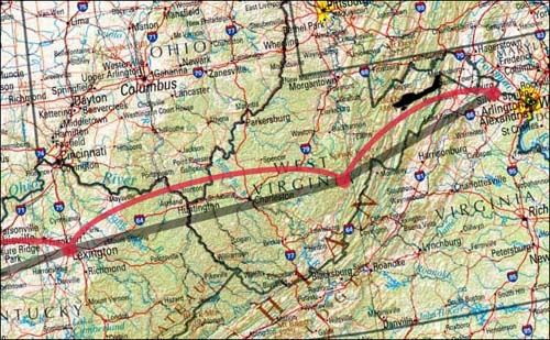
My plan was to fly to Oceano, CA, a small airport on the beach that I discovered by searching through the airport directory. I had no detailed plan for how to get there, other than to fly towards El Paso. I would plan the trip a leg at a time. The first leg was from Leesburg, VA to Sutton, WV.

I had never been to Sutton, WV, but the various directories said that it had self-serve fuel, which meant I could get gas 24 hours a day. I figured I would start my trip with a quick early morning pit-stop at Sutton and make a lot of distance the first day.
The airport at Sutton was deserted when I arrived. Not surprising for early on a Saturday. I did not really mind that the place was deserted until I discovered the lock on the self-serve fuel pump.
Luckily a guy that lives on the airport was rustling about and he knew the combination for the lock. I fueled up and then went to the lounge to hang out for a bit. For a remote and small airport the lounge was nice. It had all the standard amenities: couch, rest rooms, phone, weather, internet connection, place to lay out charts, etc. The lounge building looked a little out of place. It was a new brick building with many windows.
I laid out the chart and looked at the next leg. I already had a few candidate airports in mind for the next stop. Based on the amount of gas I put in when I refueled I verified the fuel burn rate was as expected, which made me feel better about a longer leg. I talked to the weather briefer and got the update on a front that I was flying towards. It looked like I could fly to Lexington and arrive about 90 minutes before the rain and weather.
After filing my flight plan I was soon back in the air. I was flying directly into the wind, but the winds were light, only about 10 knots. I flew north of Charleston, WV and directly over Huntington airport on the way to Lexington. The visibility continued to be good and I took in the various rivers, and foothills along the way.
Since I was past the major mountains I could fly low, about 1,500 to 2,000 feet above the ground. East of Lexington is all horse farms. I looked down and could see horses running around in packs, erratically steering around like a school of fish.
The weather, arriving from the west, was in a race with me, arriving from the east. The race to Lexington between me and the cold front ended in a tie. I arrived in light rain and marginal visibility. It looked like Lexington was a good choice for a stop.
On the ground I checked the weather. The new forecast predicted poor conditions for the rest of the day and into tomorrow morning. So I decided to stay in Lexington. I splurged and put the Aerobat into the hanger to keep it out of the rain. The Aerobat looked out of place in the huge hanger with the various business jets.
With time on my hands I decided to do a little exploring. I called the tower on the off-chance that at some point that afternoon or evening they might be able to give me a tour. The guy that answered was friendly and said I could come right over. He even offered to pick me up.
The tour started off in the radar room. The radar room was a dark room with a line of radar scopes. There were not many airplanes and one person was manning a single scope. During busy times they might have up to three folks handling different regions. I sat down at one of the empty positions.
The scope was very old school. It was circular, with the green line sweeping around the scope like you seen on old movies. The planes show up with their altitude and airspeed as well as other identifying information that tells the controller how to route the plane.
To hand a plane off to the next controller, the controller can mark the plane in such a way that it will start flashing on the next controller’s scope. When the next controller accepts the flashing plane the first controller tells you something like: “Contact Indianapolis Center on 125.35”
Sometimes controllers need to verbally communicate with controllers in another radar room (ex: Lexington might need to talk to Louisville). For that they have a set of buttons like intercom buttons. They press the button, and talk, and their voice comes out a loud speaker in the other scope room.
After checking out the radar room we took the elevator up to the control tower cab. The first impression I had was: “What a great view.” Obviously it is no coincidence that the control tower cab has a very expansive and unobstructed view of the airport and surrounding area.
The controller in the cab (what they call the glass box at the top of the control tower) is the guy that tells you when are cleared for take off or cleared for landing. He has his own scope to see the traffic lined up for landing, or possibly crossing the departure end of the runway. It was not very busy, but there was a slow trickle of traffic to watch come and go. It was very relaxed atmosphere and my tour guide, the controller in the cab, and myself hung out and watched the airplanes for while. The tour was easily worth the flight out here.
I could have hung out all day, but eventually they kicked me out. So what should I do next? It turns out that there is a museum on the field, so with time to kill I decided to check the museum out. It was a slow day at the museum and one of the volunteers gave me a guided tour of the collection.
The collection’s theme was aviation. I cannot be more specific than that. It ranged from a plane built in 1908 by a local Kentucky resident to modern military helicopters. They had gliders hanging from the ceiling, an old Waco bi-plane by the door, some old 36-cylinder radial engines, modern jet engines, three flight simulators (two of them that work), a replica of the Apollo 11 command module on loan from Langley, VA, it was endless. All in the space of a single (albeit large) hanger. They even let you get into one of the helicopters and I could move the controls around. All cool stuff.
The forecast turned out to be off. The rain ended, the sun came out, there was no wind, and the birds are chirping. I learned a lesson that first day: “Don’t commit to a hotel room until it is dark.” Who knows what the weather will do. I could have easily flown another few hundred miles this afternoon. On the other hand I had a great afternoon hanging out around the airport, so maybe there is another lesson to be learned in that.
I had my various charts (when flying you call maps charts for some historical reason) laid out all over the hotel. The forecast looks good for leaving here tomorrow, mid-morning, and it looked like I would probably get a full day of flying in. The two day forecast was not so good, showing enormous areas of rain and snow that were moving east from the Pacific coast. We’ll see. The best I could do was to plan to head west.


