High Mountain High
By: Joel Strait


Chapter 2
We topped the Bozeman (BZN) airfield by 4,000 ft. AGL and breezed right on into Butte (BTM) about two o’clock. A Buffalo Burger at the airport lounge, 14.2 gals. of gas and we were on our way again in perfectly clear sunny weather. Hal took off first with no airshow and headed out to the north on 1-90. I lost him as he climbed out sharply above me.
The “Spirit of St. Joe” loves it’s sea level home in Florida. Even on 100 degree days, it’s 69-48 McCauley climb prop produces decent climb. So why wasn’t I climbing? Sure I had a full load of gas, but I was solo and light on luggage, so why wouldn’t she climb? Let’s see, it’s mid afternoon, it’s hot, Butte is 5,545 ft. above sea level and there isn’t much wind. There went the end of the 9,000 foot runway and I’m only at a 100 feet, here comes the slope of the mountain for the 6,453 foot Pipestone Pass to the south. I turn west from the airport over sparsely settled houses climbing about 50 ft. a minute. Concentrating on climbing, I miss the interstate and head too far west. Finally Hal pipes up, “Where are you?” I try to tell him, but I’ve never been here before. At least I’m over a well traveled highway and now I’m climbing.
I take a deep breath and lo on round. I’m too far west, and not over I-90. “I’m going to Drummond (DRU) on the GPS, we can meet up there,” Hal instructs. Then he asks, “are you lost?” “Well, I’m not where I want to be, but now I’m heading for Drummond ” I answer, still climbing to clear the 8,000 foot ridges to the north. Soon I’m at 9,000 feet looking down the rugged north slope of 60 miles of mountains between Butte and Drummond. Off to my left is a black rain cloud but the rain is not hitting the ground. I spot Drummond and began to feel in charge again. The mountain says, “not just yet boy.” I’ve let the rain cloud get too close. A sudden violent downdraft picks me out of the seat and slams my head into the top of the cabin! Here’s that rough mountain air Hal warned me about. The 150 banged around a few more gyrations and then finally galloped away from the rain clouds toward Drummond.
Back over I-90 west of Drummond I turned around to take stock of “the rest of the story.” Everything I had fastened hard up against the seats was now in a pile against the back of the luggage compartment. I undid my shoulder harness, wondering why it hadn’t held me in place better, reached my gear and put the weight back where it belonged. That was all the rough weather I wanted for the rest of the trip. I didn’t get anywhere near a rain cloud after that.
10,000 feet seemed like a good altitude between Missoula, MT and Cour d’Alene, ID. Maybe it was later in the day, but it felt as smooth as ice skating on the frozen Mississippi river. No turbulence at all and yes, a tailwind. The afternoon sun shone down on peaks capped with cold white stuff. All the higher ridges wore Ermine Stoles along their crests. It’s beautiful country, but a bad place to go down in an airplane. We played it safe, never straying more than dead engine gliding distance from that four lane ribbon of safety.
GPS navigation has made me a lazy flyer. Twenty miles out of Cour d’Alene, I got a hard lesson in reality when my Garmin 90 GPS quit. Hal suggested, “turn it off for a minute or so, it’ll come back.” Five miles from the airport, it finally did, but it was back to basics for long enough to really appreciate the “new way.” Sectionals were like old friends with a language of their own, like an Instructor in the passenger seat giving advice.
We decided to surprise Greg Delavan, the airport manager at Cour d’Alene, and didn’t call ahead. Bad idea. He left the premises just before we arrived. We finally got him on the FBO phone. “I’m sorry Joel, you should have called. There is a loggers convention in town. I doubt I can get you guys a room. Let me see what I can do and I’ll call you back.”
Hal I and I were beat. We just put on 9 hours of flight time from Custer, SD. Hal disappeared for a few minutes. I found him on a phone in the weather briefing room. “I just talked to my brother-in-law in Pullman, WA, 70 miles south of here. He says he has room for us and then some.” A quick call back to a relieved Greg and we were winging our way south. It’s amazing what a pit stop, some cold water and a little walk around exercise will do to perk up weary travelers
Lengthening shadows, and dark green oceans of wheat waved through the Palouse River farmland as we set up for landing at Pullman Moscow Regional airport (PUW). Pullman is the home of Washington State University, where Hal got his degree in Electronic Engineering. Hal’s brother-in-law, Gary Cochran, met us and helped get our luggage to the truck. I knew I was really be tired when I let him carry most of my stuff without feeling guilty. I was winding down fast, and couldn’t muster a full sentence.
The road we were on was definitely off the beaten path. I’ve lived in the country but have never seen so many turns and curves and up and down dusty field roads. We finally parked beside a huge metal building next to Gary’s Rock Crushing business, run by his sons Matthew and Mark. I ambled around in a daze trying to take it all in.
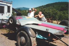
Mark invited us out back to watch him shoot his home made cannon. I imagined it was going to be some kind of Civil War miniature and thought, “how cute, maybe it will wake me up.” How do I describe this thing? All the equipment used in the rock crushing business was bigger than life. Mark’s cannon used a 3 foot long hydraulic cylinder off an old front-end loader for the powder chamber. He welded a 12 foot seamless pipe over the ram plate hole and bolted the plate to the powder chamber. It wasn’t clear how Mark was going to load powder into the chamber.
The technique was pretty amazing: First Mark forced a beer can full of frozen water down the barrel with compressed air. Next he lit a propane torch and smothered the flame out on the sole of his boot. He stuck the hissing nozzle of the torch into a small hole in the powder chamber and filled it with propane gas. Ignition spark came from a battery charger hooked up to the rear of the cylinder by a small wire. This was all done with the whole contraption laying on the ground. Does it sound like I’m awake now? The closer we came to shooting the thing, the further I hung back, till I was behind an 8 foot tall scarred rubber tire on a nearby loader.
Mark and Matthew hooked up the end of the cannon to some cables attached to a fork lift. As Mark lifted the contraption, Matthew sighted down the side of the barrel, aiming it at a truck sitting 100 yards away atop the 80 foot high edge of the Rock Pit. “We aim at it, but we’ve never hit it,” Mark laughed, while taking another look up the cannon barrel towards the target. Hal did the honors, touching wires together for the first shot. Nobody paid any attention to me. If they would have looked my way all they would have seen was one eye peeping around the tire! The exploding propane rattled my teeth. It was VERY loud! We all saw the beer can ordinance heading for the truck in a very pronounced arc. It missed the truck’s hood by about 3 feet. The next shot hit the Basalt wall about 4 feet below the lip directly under the truck.
Each shot required another beer can, which was obligingly emptied by the shooters. Adjustments to the fork lift were mandatory before each shot. What an operation. All very scientific, with lead angle, windage, velocity and trajectory taken into account. By now I was an old hand, even venturing almost out in the open.
Each time the cannon was fired the barrel got hotter, soon everything had to be done rather quickly before the ice cannon ball melted. WHAM! This time the green beer can flew true. With a resounding “thunk” the can and ice shattered dead center on the door of the truck! The sound of the cannon echoed out of the rock pit. For a moment no one said anything. Then Mark burst out, “we hit it! I don’t believe it. We’ve been shooting at that truck for years. That’s the first time we ever hit it!” I had witnessed a true milestone. Mark’s engineering degree paid off and he was now free to move on to bigger things. Bigger cannons that is. But at the moment food was foremost on our minds, so we headed downtown for supper. That night I must have lapsed into a coma. I don’t remember getting into bed after my shower.
Shortly after takeoff Saturday morning from Pullman I called Hal. “I thought CNN said there wasn’t going to be any bad weather from here to the coast today.” Hal agreed, then I asked, “what’s that tall cloud out there ahead of us then?” “Look’s like a cloud build up,” Hal noted. Only a minute or two passed when his voice came back, “you’re not looking at a cloud, Joel, that’s Mt. Rainier and we’re still a good 175 miles from it.” Not long after that another tall cloud appeared on our left. It was Mt. Adams. The scene took my breath way. Cars and even people could be seen clearly on the ground at 6,500 MSL. We took a slight detour, bypassing Yakima/McAllister (YKM) to the south before being swallowed again by high mountain ridges and valleys.
No more funny sounds coming from under the cowling. No more pinching material from the Cessna seat. No more wondering if the 150 was up to all this. Not overconfident, just feeling good about being up here and seeing all this grandeur from on high.
As we cruised over Riffe Lake south of Morton, I followed Hal towards his dad’s farm. “I’ll make the first pass and you follow me in,” Hal said. “After you make your pass go ahead and start back for Morton, I’ll do a little show and probably beat you back to the airport.”
The Morton Airport was marked Strom (39P) on my chart. There were two ways into it, both through saddle backs in the Mountain. The runway was 27-09. Zero-niner came over town, power lines, Highway 12 and tall Poplar trees. Coming in from the east for two-seven was over open farms, meadows and a sawmill just past the saddle back. A light breeze up the valley lifted the windsock tail towards the east. A C172 heard us on 122.85 and said he was high over Morton. “No traffic in the area and land towards town,” was his welcome advice.
Hal caught up with me over town. “Go ahead and land Hal,” I suggested, “I’ll make a long downwind and come in behind you.” OK, see ya on the ground,” he answered. I watched the steep slope of the timbered mountain off my right wingtip out of the corner of my eye and watched Hal settle into his final for Morton on my left. (Which ain’t a bad trick for an old bald headed one eyed guy). I dropped the left wing to start my base leg when the pilot in the 172 above us said:
“You’d better get down there quick, Your buddy in the biplane just crashed!! “
I raised my left wing to take a look, not really believing what I had heard. There was no biplane on the runway. I couldn’t see Hal anywhere. Instinctively I did what was necessary to land quickly, straining to see where my friend was. Scooting down the narrow short runway (20 feet by 1,800 feet) I saw Hal stand up and wave from his overturned plane that was nearly invisible in the five foot deep tall grass filled ditch. Slowing and turning as quick as I could, I taxied back and stopped to the side of the blacktop. Hal wears a 5 point aerobatic safety belt that holds him tight into a special wrap-a-round seat he designed. He didn’t get so much as a bruise to his hide, just his pride. Pride and joy I should say. Two years of pretty steady labor and beautiful workmanship lay in a heap almost buried in the ditch.
Hal’s brother Herman pulled up in his pickup without saying much. He just wanted to know Hal was all right and then accepted things the way they were. He’s a pilot too and knows stuff can happen.
We spent Saturday afternoon and Sunday getting the biplane apart, taking it back to the farm and putting it up in the hay barn loft. Sunday evening, we ate grilled steaks by Herman’s hanger and talked of flying again. Hal was not as depressed as I would have been. “We’re so close to the coast, Hal, I’d really like to go fly out over it in the 150. How about coming along?” I asked. “Sure, why not,” he said eagerly. My kind of pilot.
Taking off into the wind towards the eastern saddle back at Morton the next morning was not as bad as expected. We took all the baggage out and had about 12 gallons of gas on board. I learned to fly on a 1,800 foot grass strip in Iowa, with a 6 foot high train embankment at the end, so I just turned those 100 horse loose and let it find it’s way into the sky without prodding.
Morton “Airport” is really just an old road east out of town. It’s only 20 feet wide with deep drainage ditches on both sides. (Unfortunately for Hal.) If the road toward town wasn’t fenced, you could taxi three blocks to the restaurant in the middle of town. The runway would dead-end into a north-south road to the east but for having it’s end dug out and railings on both sides of the other road.
Crossing the saddleback we turned west over Riffe Lake. Touching down at Toledo-Winlock Memorial Airport (TDO) was a return to civilization. I could have landed crossways on the 4,900 foot concrete acreage out here in the middle of nowhere. Sadly, another dead FBO.
Gassing up, we headed for Seaside Oregon, thirty-five miles from the Pacific. We flew over a ridge and onto a low lying blanket of clouds so bright it hurt our eyes. A few miles later I saw a hole to my left. “I’ll never see the ocean this way, Hal, I’m going to try to get under this stuff, ” I said, throttling back and heading for the opening. We could see the Columbia River through the hole so just slid down and leveled off about 500 feet above an island. Heading down the river Hal noted, “Joel, it’s not getting any lighter ahead of us.” He was right. We turned easily across the widening river and headed back, to that same hole and popping back out on top. Odd that the hole stayed right there for us.
The GPS indicated we were over Seaside (56S) and heading out over the Pacific. Next gas stop, Japan. We flew out 10 miles or so just to be able to say the “Spirit of St. Joe” had done it. It wasn’t quite what I’d envisioned, day-dreaming about this part of the trip in my den in Florida .
That eye numbing blanket was starting to turn pink even through UV shades over my UV prescription glasses. Reluctantly we turned back. Hal dialed in Astoria’s ASOS, 10 miles north of our position. The reported ceiling over the Astoria airport (AST) was 1,300 feet and rising. That just made me want to cry. We were flying above as solid a deck of clouds as I’ve ever seen and it was nice and clear underneath. We went about 25 miles back on the reciprocal heading toward Toledo when I spotted another fair sized hole in the cloud deck. “Look, Hal, “I think I can see all the way to the ground.” Hal leaned over and agreed, “you can.”
Carb heat on, throttle to 1,800, down we went. Oh come on now, the same exact place on the same Island? It was then we realized what kept that hole open. A large paper mill on the island plumed hot air and steam into the sky, keeping the thin layer of clouds at bay.
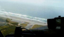
The clouds were still low, about 600 feet, but the light at the end of the tunnel kept getting brighter. Astoria ASOS was accurate to a fault. We climbed to 800 feet to clear the edge of town. Low and behold there on the west side of the airport was the blue Pacific Ocean! I got so excited I had to land for a pit stop before flying on. Hal got some low altitude pictures of people surf fishing with their cars parked right out on the beach.
We spotted a large ocean going ship heading for the mouth of the Columbia River, over flew it and then headed up the Columbia ourselves. Thirty-five meandering miles later over native Indian fishing stockades and more ocean size ships we broke out into cloudless sky. Mt. St. Helens looked close enough to touch but was still 50 miles dead ahead. The distance closed slowly as the Spirit climbed into her element. Leveling off just below the rim of the mountain crater, we began a slow picture taking circle. Not even a wisp of smoke could be seen. The mound in the middle of the abyss had stopped growing. It’s dormant, but I had an eerie feeling that we didn’t need to be spending too much time right in the front door of the sleeping Giant.
Turning north, we flew over Spirit Lake. It was still full of half floating logs. Ash appearing as dirty snow covered the slopes of the mountain and most everything else for miles in any direction. The sparkling clean look of a new Visitor’s Center stood out in stark contrast against the rest of the landscape.
Back at Herman’s place on Sunday evening, we watched Herman fly his single place Terratorn Ultralight. Herman’s short private runway is uphill for landing, downhill for take off. The second time around the hill the Terratorn faltered on a steep pull up and went out of site behind the hill. When it didn’t come back up, and we could no longer hear the engine, I started running over the hayfield hill, dreading what I might find. The plane was down in tall grass with Herman standing next to the engine. “It blew a sparkplug clean out of the cylinder,” he noted dryly, but “Everything is all right.” Hal and Barbara soon arrived to help pull the ultralight back to the hangar. I couldn’t help think to myself, “Ok, that’s two….am I next?”
Monday morning Herman drove Hal down to the Toledo concrete field with all our belongings. Toledo Airport lay in a wide valley at 375 feet ASL. All the heavy stuff went up against the seats again but my gosh, the whole baggage area was full clear back to the rear window. Hal punched in 15 gal. on the credit card gas machine. “Make that 18, Hal, I think it’ll take it.” I suggested. The left tank held 11 up to the cap and 7 went into the right tank with room to spare. It was only a two and a half hour flight straight to Pullman. No point in carrying more fuel weight then necessary on top of all our other payload. A close count showed the load was going to be 1,650 lbs., well under the 1,760 lbs. the new Aircraft Directive placard on the 150 Instrument Panel said I could carry.
The Spirit lifted off to the west into a nice headwind so easy I could hardly believe it. We turned south toward the Columbia and breached it over the Cascade Locks. A thirty-five MPH tailwind blew us along the river so fast I barely had time to enjoy watching hundreds of windsurfers at Hood River. I punched Pullman in on the GPS and we left that scenic, watery interlude for a straight shot to Pullman over the winding Snake River. Fifteen miles from Pullman, with the city in sight, the GPS quit again. This time Hal had his new Lowrance GPS tuned in, but by then we didn’t need it.
Pullman was the only place we could buy 80 Oct. Avgas on the trip. Probably because there were so many old round engine AG Planes in the area. “Do you have long range tanks in your 150?” the FBO at Pullman asked me the next morning. “No why?” “Well, my gas man just turned in a fuel slip for 22.8 gallons.” . If we had 20 gallons on board when we left Toledo that would make the hourly burn with a full load 5.8 GPH. I did notice that I had to turn 2,650 to stay “on the step.” When I told Hal, he about croaked. “I guess we should not have gone down to the Columbia.” he said, shaking his head.
On departure, we needed full power to clear the Mt. ridges east of Pullman, which drove the oil temp gauge almost to redline. Leveling off at 7,500 feet the gauge quickly slipped back to normal. Now that we knew what to look for, we spotted two long defunct volcanoes enroute to Butte. The smaller and less visible of the two, Eagle Peak (I think) is just south of 1-90 and DeBorgia, MT. The second VERY visible volcano is Southwest of DeerLodge City-Co. Airport (38S), north of Butte. The rim of this hollowed out massive still tops 10,000 feet with a huge slumbering mound in the middle, looking like a big brother to Mt. St. Helens.
About three hours out from Pullman my personal gauge read full again so it was time for a pit stop at Butte. Three miles or so on a long final for Butte we were startled by a loud POW!! and something green shot by the windshield. No vibrations, gauges all normal. “What the heck was that?” Hal sang out as we steadily descended. “The only thing green ahead of the prop is the prop spinner,” I sang back. “I think we hit a bird, but I don’t see any blood,” Hal ventured while craning his neck around the cockpit windows. “Check the wheel pants, they’re green,” I suggested. We could only see the wheel pants on the mains so didn’t know what to think about the nose gear pant. By now we were committed to land. As big as Butte is, they don’t have a control tower or we could have flown by for a gear check. Hal kids me… how slow can I land the Cessna with full flaps?
I always use full flaps so my little girl doesn’t have to take any more abuse than necessary. The mains touched down at the same time the stall warning horn beeped. I held the nose off longer because of the weight aft of the seats. Using rudder, I eased the Cessna over to the side of the runway and then let the nose down. the 150 rolled out without so much as a shimmy all the way to the tie-down ropes.
My contribution to the City of Butte that day was a nice green spinner and backplate. The backplate sheared off tight around the bolt holes between the prop and the engine prop flange. It had been slightly off center for some time but hey, very few spinners I’ve seen run perfectly true.
It was barely noon when we readied for take off. Full load again for the jump to Sheridan, WY. I did the run-up check on the taxi-way back from the north end of the runway. A light wind wafted from the south down the 9,000 foot up-slope course. Checks complete, throttle up for a fast turn out onto the black streaked concrete path. Trundling into the air after about a 800 foot run we settled into ground effect flight. “C’mon Girl, I know you can do it,” I gritted to myself, leaning the engine for every last ounce of RPM she could muster.
We were only out of ground effect by maybe 30 feet when the south end of that beautiful runway disappeared behind us. The rise in the slope ahead was coming up faster then we were. Oops! Been here, done that! I turned slowly to the right. Now we were parallel to the runway again but at least the ground was falling away. We weren’t actually climbing much, the ground was just getting farther away. I crossed back over the center of the runway and kept turning till we were headed into the wind again. Airspeed was edging up toward 75 but now the climb needle indicated a blistering 150 feet per minute heaven-bound ascent!
I glanced over at Hal. He met my look. For the first time on the trip he didn’t have anything to say. We cleared the I-90 saddleback to the east by 800 feet still climbing. It wasn’t pretty, but we made it.
The last snow capped series of 11,000 foot mountains southwest of Sheridan, WY came too fast, too soon and too early in the day. We had another one of those days where flying was too great to put to bed.
The voice activated cockpit intercom sure made it easier to carry on a running conversation with Hal. Before, when we were in separate airplanes, my thumb would actually get tired from pushing the mike button as we discussed our cross country progress. We landed at Sheridan with only seven hours under our belts and lots of sunshine left. As the trail boss said to his cattle drive companions, “daylight is burning boys.” We stayed in Sheridan just long enough to hang on a muzzle bucket of oats and then galloped on.
The Devils Tower National Monument Airspace north of the Black Hills is very small. How small? We circled the rusty clay colored megalith within a half mile on the South and East for pictures and didn’t penetrate it. Landing at Black Hills Clyde Ice (SPF) Airport east of Spearfish, SD gave us 8 hours and 36 minutes of airtime for the day. Plenty of daylight left to get to a motel and a hot meal before dark. We treated ourselves to a good Applebee’s Steak and turned in for the night at the motel next door.
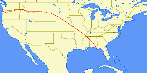
The next morning we journeyed away from the Dark Hills past rows of ominous Ellsworth AFB Bl-B Bombers and the real reason we had come west. No more gaping out onto real-estate higher than the top of the cabin. The mountains were no longer a foe to conquer. Now they were friends to embrace, beauty to share and thrills to extol. Hal used his GPS as a trip planner for the straight trek to Panama City, FL (PFN). I marked it on the sectionals with a green highlighter pen. The only airport we flew into using a control was Jonesboro, AR (JBR) and that was a Flight Service Station not a control tower. Another nine and a half hour day contributed to planting all three tires firmly at the same time without much flair. Well, okay, no flair. The 150 forgives me when I’m tired. One more reason why I love her so.
Bumpy air greeted us first thing in the morning and increased steadily as the day wore on. The 20 MPH tailwind rushed us around the 30 nautical mile Mode C circle at Memphis and flung us south eastward. Rough air made for tiring flying. The 150 took some really solid hits and jolts. Not fun. After gassing up at Selma, Al Graig Field (SEM) we needed more downtime before going on. We drove the white 67 Buick courtesy car off the old Army Air Force base, through abandoned barracks, officers club grounds, and past an unused looking church. Empty business buildings along Highway 80 gawked at us through dark picture window frames.
A filling turkey club sandwich at a local businessman’s lounge made us almost reluctant to get back into the air. Almost, because now it was really getting rough. One hit was so severe Hal grabbed for the hand strap on the windshield post as the 150 slammed over 50 degrees.
Haze was thick, we were down to 800 feet AGL just to see the ground three miles ahead, and this is tower country. Lots and lots of towers. We were past the 1,700 plus AGL stuff but still had gobs of the 500 foot kind ahead. By afternoon thunderheads were building their towering black bottomed threats to the east. Decision time. While we were pondering our plight I noticed we weren’t being thrown about quite so much. My imagination, or wishful thinking? Hal confirmed it by observing, “It’s not as rough now, is it?” The buildups were still there, but a strong onshore breeze from the Gulf of Mexico kept them at bay.
Pulling up to the Chapter 202 hanger at Sandy Creek was a welcome relief. Hal’s daughter, Jamie, came out to pick up my navigating friend and half the luggage load. After shutting down, unloading and tying the Spirit to her home moorings, it just didn’t seem right to leave her.
We lost a $340 Alternator and a $400 Prop Spinner. We covered her belly with oil and loaded her on the heavy side. We drove her through some really rough turbulence and the GPS went down twice. She took a lickin and kept on tickin. I could buy bigger. I could buy faster. But for what I want out of an airplane I couldn’t buy better.
Would I like to go back to flying High Mountains High? Ask me next year… but next time, could we make it two months instead of one?