


What I Did On My Summer Vacation, 2003
By: Nick Wener
I secured our bags in the luggage area of our 152. My wife stood under the wing as a morning rain shower passed over us. To the east there were a few clouds with long patches of blue in between. To the northwest it was dark with misty rain and distant lightening, moving toward us at 25 knots.
With coffee in our cup holders we taxied to runway 11. The wind was calm. As we climbed to altitude dark clouds and distant lightening flashed off our left wing.
We leveled off at 5,500 in a blue sky, dotted with white clouds. I contacted Kansas City Center for flight following to Quincy, Illinois. Vicki thumbed through a magazine about Log Homes and where to build them. She’s planning our retirement.
With a strong tail wind producing a ground speed of 115 knots we made excellent time to Quincy. Our descent was smooth until we passed over the Mississippi River. On the downwind for runway 21, the ride was again smooth, all the way to the ground.
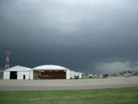
We taxied to Curtis Aviation and parked the airplane. One Hundred LL was $2.64 a gallon, a little high, but the service was excellent. Inside, Vicki went to the pilot’s lounge to make us each an egg salad sandwich and pour a glass of lemonade, while I checked the radar screen and called Flight Service.
On the screen there was a line of storms, stretching northwest of Chicago toward the southeast. The line looked to be 60 to 70 miles long. Flight Service said they were unpredictable at this point. Earlier, a line of storms developed in the same area and then fell apart. My next scheduled stop was Kankakee, 25 miles south of Chicago.
“There’s a NOTAM for Kankakee,” the briefer said. “A landing reservation is required.”
There was a NASCAR race in Chicago and Kankakee expected the overflow from Chicago’s Midway. I called for a reservation.
I went back to the pilot’s lounge. The Chicago NASCAR race was on TV. “How does it look?” Vicki asked. She handed me a sandwich.
“Thunder storms developing north of our route,” I said. “They could give us trouble.”
Leaving Quincy I contacted Kansas City Center for flight following and was soon handed off to Peoria, as sky conditions began to change. We flew into mild turbulence at 5,500, as the wispy clouds we had encountered earlier, grew larger. Halfway to Kankakee we were handed off to Chicago Center. To the northeast of us a distant line of cumulus clouds were building. They had a pinkish hue. I requested a frequency change to contact Flight Watch. “Change approved,” Chicago said. “Report back.”
I asked Flight Watch about the line of storms I had seen earlier on the screen at Quincy. The briefer said the storms were well developed and tracking southeast, with hail, and winds in excess of 40 knots. I gave him my position and ground speed and asked if he thought we could get to Kankakee ahead of the storms. “I’d advise against it,” he said. “You’re close to Pontiac. Maybe ten miles. The identifier is Poppa November Tango.”
Back on frequency I waited for a break in the dialogue. Chicago Center was advising other aircraft to divert to Pontiac. In all there were 6 aircraft diverted to the Pontiac Municipal Airport. I informed the controller of my intentions and he terminated flight following.
My wife was unfazed by the turn of events. She understood that summer flying meant navigating around summer storms. Stay in touch with Flight Watch and you won’t fly into any surprises.
Out of the 6 aircraft diverted to Pontiac we were the closest to the airport but as the only 152 in the crowd we were also the slowest and the last to land. No surprise there.
Vicki collected her things as I tied down the airplane. To the distant north a wall of dark clouds, with veins of lightening, moved toward us. To the south and west there was sunshine.
Inside the terminal building there was free coffee, snacks and soda pop to purchase, and a stack of newspapers. Vicki picked out a current issue of the Wall Street Journal and sat down at one of the tables. Along the wall there were a half dozen computers logged onto the weather service. Several pilots were gathered around one computer, discussing and pointing to the red and yellow cells moving across the screen.
Our delay lasted two hours. As the leading edge of storms passed through Kankakee a trailing line of cells had developed. Vicki was busy with the Wall Street Journal. For her the weather did not exist. She had her pocket calculator out and was jotting down figures. I married a financial planner; she married a pilot. I won that one.
Outside, the weather had finally cleared. I untied the airplane and purchased fuel. Vicki came across the tarmac with a folded newspaper and a notebook under her arm.
“That’s our line of flight,” I pointed. “Just north of that rainbow.”
I contacted Chicago Center and requested flight following to Coldwater, Michigan. The sun was behind us now. The afternoon light softened. We passed ten miles north of the Kankakee airport. It was hard to imagine violent weather over such a pastoral sight.
As the city of Chicago came into view from 5,500 so did the dark clouds and veins of lightening east of the city and over Lake Michigan. To the east and southeast of us there was hazy sunshine. Chicago Center handed us off to South Bend. Our line of flight was east, northeast. The dark curtains of rain and occasional lightening seemed to follow off our left wing. Flight Watch advised we fly 090 for 7 miles and then resume navigation.
At Coldwater, Memorial airport the wind was 240 at 9 under broken skies of orange. The fuel was self serve at $1.99 a gallon. We both needed to use the bathroom but the FBO office was locked. We taxied to the end of runway 21 and across an empty field to the Airport Restaurant.
Leaving Coldwater we leveled off at 3,500, beneath broken clouds, with a ground speed of 110 knots. The sun was setting on a horizon of treetops. The GPS screen switched to night mode.
We flew past the lights of Lansing and on toward Flint. A helicopter crossed our light of flight, 1000 feet below us. I did not receive a “traffic advisory” from approach and thought maybe I was off frequency. I asked for a radio check. A young woman replied, “46212, read you loud and clear.” Vicki looked at me, as if to say, “Let it go.”
GPS had us 8 miles from our waypoint of Caro, Michigan. The night was pitch black. The populated areas were well to the south of us. I keyed the mike 5 times and the runway lit up like pinball machine. Strobe lights marked the approach of runway 26. We turned base. The wind was 240 at 15 knots. As we descended to 500 feet we flew into strong turbulence. We touched down on one wheel.
We taxied to the FBO, tied down and removed our bags. From across the tarmac my sister and brother-in-law drove up. My brother-in-law, a pilot and owner of a Cessna 140, said he had been worried about us. “Been watching the Weather Channel since this morning,” he said. “There were storms all along your route. All day.”
“I use Flight Following and Flight Watch,” I said. “Stay in touch with them and you can navigate around the storms.”
My sister put her arm around me. “It’s good to see you,” she said. “Both of you. We’ve missed you.”